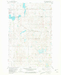
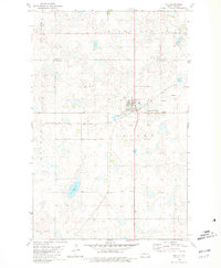
1980 Map of Douglas East
USGS Topo · Published 1981About this map
The town of Douglas sits at the northwestern edge of this 1980 survey, where the Soo Line railroad cuts across the prairie landscape. The area is defined by the high concentration of prairie potholes and wetlands typical of the Missouri Coteau, including significant water bodies such as Bartons Lake, Douglas Lake, and the aptly named Shallow Alkali Lake. The drainage network is traced by the various forks of Douglas Cr, including Mid Br Douglas Cr and E Br Douglas Cr.
Find a feature on this map
16 named features on this map. Tap any name to fly to it.
Don’t see what you’re looking for? This feature index may not catch every label — zoom into the map to look around manually.
Map Details
Editions of this 1980 Douglas East Map
This is the sole edition of this map. No revisions or reprints were ever made.
Other maps of this area

1922 · Garrison
USGS Topo · 1:62,500

1954 · McClusky
USGS Topo · 1:250,000

1956 · Emmet NE
USGS Topo · 1:24,000

1956 · Douglas West
USGS Topo · 1:24,000

1958 · McClusky
USGS Topo · 1:250,000
1974 · Garrison NW
USGS Topo · 1:24,000
1974 · Garrison NE
USGS Topo · 1:24,000

1980 · Lake Vernon
USGS Topo · 1:24,000
1980 · Max NE
USGS Topo · 1:24,000
1980 · Max
USGS Topo · 1:24,000