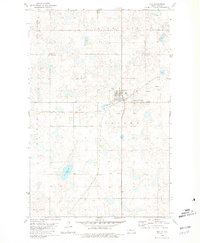
1980 Map of Max
USGS Topo · Published 1981About this map
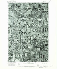
The town of Max sits at a geographic crossroads in the late 1970s, positioned where the Soo Line railroad intersects the boundary between Ward and McLean counties. This prairie landscape is defined by the unique "pothole" topography of the region, featuring numerous small water bodies and seasonal ponds alongside larger features like Springs Lake and Shallow Lake. The distribution of burial sites, including Peace Cem, Max Cem, Immaculate Conception Cem, and Zion Cem, reveals the scattered nature of early rural congregations and settlements within the townships of Rushville, Rosemount, Economy, and McGinnis. Beyond the town center, industrial activity is noted by several Gravel Pit locations, while the surrounding land is gridded by field lines and fences, many of which are specifically delineated based on aerial photography from 1973. This survey provides a clear view of the agricultural and transportation infrastructure that supported these North Dakota communities as they entered the 1980s.
Find a feature on this map
16 named features on this map. Tap any name to fly to it.
Don’t see what you’re looking for? This feature index may not catch every label — zoom into the map to look around manually.
Map Details
Editions of this 1980 Max Map
This is the sole edition of this map. No revisions or reprints were ever made.
Other maps of this area

1922 · Garrison
USGS Topo · 1:62,500

1929 · Coleharbor
USGS Topo · 1:62,500

1929 · Benedict
USGS Topo · 1:62,500

1954 · McClusky
USGS Topo · 1:250,000

1958 · McClusky
USGS Topo · 1:250,000
1974 · Garrison NW
USGS Topo · 1:24,000
1974 · Benedict NW
USGS Topo · 1:24,000
1974 · Benedict SW
USGS Topo · 1:24,000
1974 · Garrison NE
USGS Topo · 1:24,000
1974 · Coleharbor NW
USGS Topo · 1:24,000