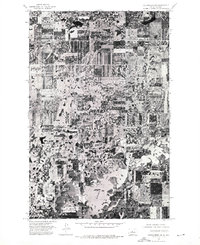
1974 Map of Coleharbor NW
USGS Topo · Published 1975About this map
Lake Audubon dominates the southern landscape of this mid-1970s orthophotograph, providing a clear visual record of the shoreline and its surrounding terrain in McLean County. This imagery, captured from an August 1974 aerial survey, showcases the grid-like pattern of the North Dakota prairie, where agricultural fields and small sloughs define the rural character of the region. The high-contrast orthophoto format allows for a precise examination of land-use patterns and water levels during this specific period, reflecting the importance of water management overseen by the State Water Commission. Unlike traditional topographic maps, this record emphasizes the actual texture of the ground and the distribution of vegetation and water bodies across the central North Dakota plains.
Find a feature on this map
1 named feature on this map. Tap any name to fly to it.
Don’t see what you’re looking for? This feature index may not catch every label — zoom into the map to look around manually.
Map Details
Editions of this 1974 Coleharbor NW Map
This is the sole edition of this map. No revisions or reprints were ever made.
Other maps of this area

1922 · Garrison
USGS Topo · 1:62,500

1929 · Coleharbor
USGS Topo · 1:62,500

1929 · Benedict
USGS Topo · 1:62,500

1954 · McClusky
USGS Topo · 1:250,000

1958 · McClusky
USGS Topo · 1:250,000

1961 · Lake Nettie
USGS Topo · 1:24,000
1972 · Coleharbor
USGS Topo · 1:24,000
1972 · Riverdale North
USGS Topo · 1:24,000

1974 · Benedict SE
USGS Topo · 1:24,000
1974 · Coleharbor NE
USGS Topo · 1:24,000