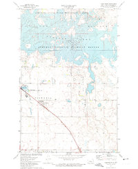
1972 Map of Coleharbor
USGS Topo · Published 1974About this map
Audubon Lake and the eastern reach of Lake Sakakawea dominate this McLean County landscape, illustrating a period of significant water management and conservation in North Dakota. The map documents the sprawling Audubon National Wildlife Refuge and the Audubon State Game Management Area, reflecting the region's focus on habitat preservation around these large reservoirs. The settlement of Coleharbor sits at the junction of local roads and the Soo Line railroad, serving as a hub for the surrounding agricultural townships of Victoria, Snow, Malcolm, and Longfellow. To the south, the small community of Gateway marks an entry point to this lake-rich territory. For those researching local heritage, the Coleharbor Cem and various rural landmarks such as a Gravel Pit and the Wolf Creek State Game Management Area provide specific geographic anchors for the early 1970s.
Find a feature on this map
16 named features on this map. Tap any name to fly to it.
Don’t see what you’re looking for? This feature index may not catch every label — zoom into the map to look around manually.
Map Details
Editions of this 1972 Coleharbor Map
2 editions found
Other maps of this area

1922 · Garrison
USGS Topo · 1:62,500

1929 · Coleharbor
USGS Topo · 1:62,500

1948 · Stanton
USGS Topo · 1:62,500

1949 · Stanton
USGS Topo · 1:62,500

1949 · Washburn
USGS Topo · 1:62,500

1954 · McClusky
USGS Topo · 1:250,000

1958 · McClusky
USGS Topo · 1:250,000

1961 · Lake Nettie
USGS Topo · 1:24,000

1961 · Washburn NE
USGS Topo · 1:24,000

1961 · Underwood
USGS Topo · 1:24,000