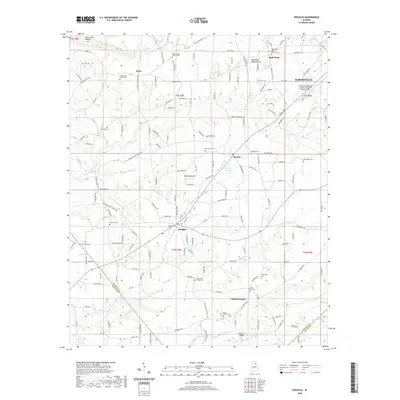
2020 Map of Douglas
USGS Topo · Published 2020About this map
Sand Mountain dominates the center of this Marshall County landscape, where the plateau terrain is etched by an intricate network of drainage including Big Reedbrake Cr and Little Mud Cr. The settlement pattern centers on the town of Douglas and the community of Horton, with the northern edge transitioning toward Albertville. This area is characterized by a high density of rural religious and funerary sites, reflecting a deep-rooted community structure. Notable landmarks for genealogists and local historians include the Liberty Hill Church Cem, Rock Springs Church Cem, and the High Point Baptist Church near the Tennessee Valley Divide. Near the southern border, the Flats Ford Bridge crosses Big Br as it flows toward the Marshall and Etowah county line, while the Albertville Regional Airport occupies the northeastern corner, marking the modern economic footprint of the region.
Find a feature on this map
169 named features on this map. Tap any name to fly to it.
Don’t see what you’re looking for? This feature index may not catch every label — zoom into the map to look around manually.
Map Details
Editions of this 2020 Douglas Map
This is the sole edition of this map. No revisions or reprints were ever made.
Other maps of this area

1885 · Gadsden
USGS Topo · 1:125,000

1888 · Gadsden
USGS Topo · 1:125,000

1892 · Gadsden
USGS Topo · 1:125,000

1895 · Gadsden
USGS Topo · 1:125,000

1903 · Gadsden
USGS Topo · 1:125,000

1936 · Guntersville
USGS Topo · 1:24,000

1936 · Mountainboro
USGS Topo · 1:24,000

1936 · Arab
USGS Topo · 1:24,000
1936 · Brooksville
USGS Topo · 1:24,000

1936 · High Point
USGS Topo · 1:24,000