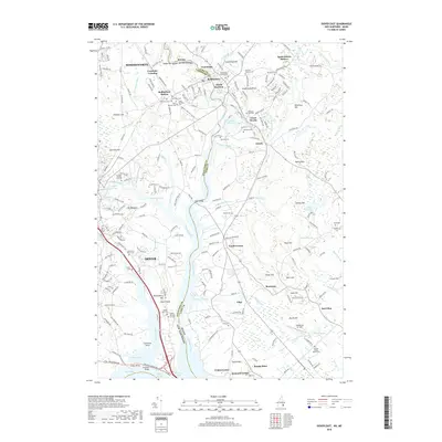
2018 Map of Dover East
USGS Topo · Published 2018About this map
The Salmon Falls River and Piscataqua River define the winding border between Maine and New Hampshire, anchoring a landscape where industrial heritage meets coastal terrain. In this 2018 survey, the area around Dover and Rollinsford reveals a dense concentration of historical burial sites, from the Quaker Burying Ground near Dover Point to the Cocheco Burying Ground and Saint Michaels Cem. The map illustrates the region's transport evolution, showing the Boston and Maine Railroad corridors alongside modern infrastructure like the Scammel Bridge. Small settlements such as Gould Corner, South Eliot, and Jewett dot the countryside, while the proximity of the Great Works River and several mill ponds, including Leighs Mill Pond, speaks to the long-standing water-powered industry of the Seacoast region. From the elevations of Garrison Hill to the tidal reaches of the Cocheco River, the map provides a clear picture of the modern interface between established towns and preserved family plots like the Shorey Plot and Preble Lot.
Find a feature on this map
233 named features on this map. Tap any name to fly to it.
Don’t see what you’re looking for? This feature index may not catch every label — zoom into the map to look around manually.
Map Details
Editions of this 2018 Dover East Map
This is the sole edition of this map. No revisions or reprints were ever made.
Other maps of this area

1891 · Berwick
USGS Topo · 1:62,500

1891 · Kennebunk
USGS Topo · 1:62,500

1893 · Kennebunk
USGS Topo · 1:62,500

1893 · Dover
USGS Topo · 1:62,500

1893 · Berwick
USGS Topo · 1:62,500

1893 · York
USGS Topo · 1:62,500

1898 · Kennebunk
USGS Topo · 1:62,500

1916 · Dover
USGS Topo · 1:62,500

1918 · Dover
USGS Topo · 1:62,500

1920 · York
USGS Topo · 1:62,500