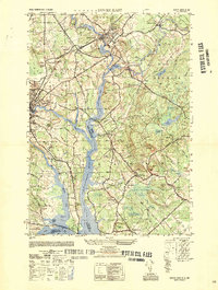
1950 Map of Dover East
USGS Topo · Published 1950About this map
The Salmon Falls River and Piscataqua River define the industrial and geographic border between New Hampshire and Maine in this 1950 survey. The landscape is dominated by the rail-and-water economy, with the Boston and Maine Railroad cutting through the heart of Rollinsford and South Berwick. Local life is anchored by numerous neighborhood schools and religious sites, such as the Pear Yard School and St Patricks Cem.
Find a feature on this map
92 named features on this map. Tap any name to fly to it.
Don’t see what you’re looking for? This feature index may not catch every label — zoom into the map to look around manually.
Map Details
Editions of this 1950 Dover East Map
This is the sole edition of this map. No revisions or reprints were ever made.
Other maps of this area

1891 · Berwick
USGS Topo · 1:62,500

1891 · Kennebunk
USGS Topo · 1:62,500

1893 · Kennebunk
USGS Topo · 1:62,500

1893 · Dover
USGS Topo · 1:62,500

1893 · Berwick
USGS Topo · 1:62,500

1893 · York
USGS Topo · 1:62,500

1898 · Kennebunk
USGS Topo · 1:62,500

1916 · Dover
USGS Topo · 1:62,500

1918 · Dover
USGS Topo · 1:62,500

1920 · York
USGS Topo · 1:62,500