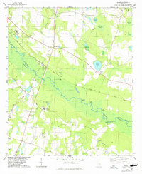
1978 Map of Dover
USGS Topo · Published 1978About this map
The Ogeechee River carves a winding path through the lowlands of Screven and Bulloch Counties, defining a landscape shaped by water and the Central of Georgia railroad. In the late 1970s, this area remained largely rural, centered on the railroad junctions at Dover and Cooperville. The riverbank is dotted with family and local river access points like Opius Landing and Hendersons Landing, suggesting a local economy and culture still deeply tied to the swampy river corridor.
Find a feature on this map
50 named features on this map. Tap any name to fly to it.
Don’t see what you’re looking for? This feature index may not catch every label — zoom into the map to look around manually.
Map Details
Editions of this 1978 Dover Map
This is the sole edition of this map. No revisions or reprints were ever made.
Other maps of this area

1918 · Oliver
USGS Topo · 1:62,500

1920 · Statesboro
USGS Topo · 1:62,500

1920 · Oliver
USGS Topo · 1:62,500

1921 · Brooklet
USGS Topo · 1:62,500

1921 · Rocky Ford
USGS Topo · 1:62,500

1943 · Brooklet
USGS Topo · 1:62,500

1943 · Rocky Ford
USGS Topo · 1:62,500

1943 · Millen
USGS Topo · 1:125,000

1943 · Statesboro
USGS Topo · 1:62,500

1943 · Oliver
USGS Topo · 1:62,500