
1936 Map of Dover
USGS Topo · Published 1936About this map
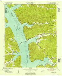
The Cumberland River dominates this mid-1930s landscape, serving as a vital artery for transportation and industry before modern changes to the river system. The historic site of Fort Donelson and the adjacent National Military Park stand north of Dover, marking the area's significance in regional history. Numerous river landings, such as Fitzhughs Landing and Shingles Landing, illustrate the reliance on waterborne commerce during this era.
Find a feature on this map
63 named features on this map. Tap any name to fly to it.
Don’t see what you’re looking for? This feature index may not catch every label — zoom into the map to look around manually.
Map Details
Editions of this 1936 Dover Map
This is the sole edition of this map. No revisions or reprints were ever made.
Other maps of this area

1931 · Erin
USGS Topo · 1:62,500

1936 · Tharpe
USGS Topo · 1:24,000

1936 · Tantrough Hollow
USGS Topo · 1:24,000

1936 · McKinnon
USGS Topo · 1:24,000

1936 · Stewart
USGS Topo · 1:24,000

1936 · Standing Rock
USGS Topo · 1:24,000

1950 · Stewart
USGS Topo · 1:24,000

1950 · Standing Rock
USGS Topo · 1:24,000

1950 · Dover
USGS Topo · 1:24,000
1950 · Mc Kinnon
USGS Topo · 1:24,000