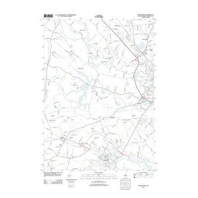
2012 Map of Dover West
USGS Topo · Published 2012About this map
The University of New Hampshire anchors the southern portion of this landscape, where the Oyster River and College Brook meet in Durham. The terrain is defined by a series of drumlins and rises, including Pudding Hill, Beech Hill, and Demeritt Hill, which separate the various watersheds. To the north, the Cocheco River winds through Cocheco toward the industrial corridors of Dover West, passing the County Farm Bridge and the Mallego Plains. This area maintains a high concentration of small family and community burial grounds, such as Durham Cem, Torr Cem, and Dube Cem, many situated near historic farmsteads like Demeritt Hill Farm. The Bellamy Reservoir serves as a major hydrological feature, fed by the Bellamy River and Mallego Brook, illustrating the mid-century water management systems that support the surrounding communities of Madbury and Sawyers.
Find a feature on this map
183 named features on this map. Tap any name to fly to it.
Don’t see what you’re looking for? This feature index may not catch every label — zoom into the map to look around manually.
Map Details
Editions of this 2012 Dover West Map
This is the sole edition of this map. No revisions or reprints were ever made.
Other maps of this area

1891 · Berwick
USGS Topo · 1:62,500

1893 · Dover
USGS Topo · 1:62,500

1893 · Berwick
USGS Topo · 1:62,500

1916 · Dover
USGS Topo · 1:62,500

1917 · Mt. Pawtuckaway
USGS Topo · 1:62,500

1918 · Dover
USGS Topo · 1:62,500

1919 · Mt. Pawtuckaway
USGS Topo · 1:62,500

1919 · Alton
USGS Topo · 1:62,500

1933 · Berwick
USGS Topo · 1:48,000

1937 · Berwick
USGS Topo · 1:62,500