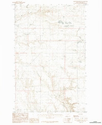
1984 Map of Down Reservoir SW
USGS Topo · Published 1984About this map
Milk Creek winds through this northern Montana landscape, anchoring a drainage network that includes Dodson Creek and Black Creek. This 1984 provisional survey captures the open, high-plains character of Blaine County, where subtle elevation changes are marked by landforms like Eureka. The map reflects the vast township and range system typical of the West, with grid lines for T33N and T32N defining the spatial organization of the territory. The intricate contour work reveals the drainage patterns of the various creek systems as they cut through the Montana prairie, providing a detailed look at the physical geography before modern land-use changes might have altered these small watercourses.
Find a feature on this map
5 named features on this map. Tap any name to fly to it.
Don’t see what you’re looking for? This feature index may not catch every label — zoom into the map to look around manually.
Map Details
Editions of this 1984 Down Reservoir SW Map
This is the sole edition of this map. No revisions or reprints were ever made.
Other maps of this area

1903 · Wayne Creek
USGS Topo · 1:62,500

1905 · Wayne Creek
USGS Topo · 1:62,500

1913 · Cherry Ridge
USGS Topo · 1:125,000

1920 · Avery
USGS Topo · 1:125,000

1953 · Havre
USGS Topo · 1:250,000

1957 · Havre
USGS Topo · 1:250,000

1958 · Havre
USGS Topo · 1:250,000

1964 · Wayne Creek SE
USGS Topo · 1:24,000

1964 · Coburg
USGS Topo · 1:24,000
1964 · Savoy
USGS Topo · 1:24,000