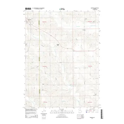
2015 Map of Downing
USGS Topo · Published 2015About this map
Downing serves as the primary hub in this rural landscape along the border of Schuyler and Scotland counties. The terrain is defined by the winding paths of the N Fabius River and the N Fork Middle Fabius River, which create a complex network of ridges and valleys occupied by small settlements like Middle Fabius and Crawford. The map reveals a high concentration of local burial grounds, including the Downing City Cemetery, East Lynn Grove Cemetery, and the McGrady Cemetery, providing significant data points for genealogical research in this part of Missouri. The drainage patterns of Bridge Cr and Wildcat Cr illustrate the natural runoff toward the Fabius branches, while landmarks such as Rowland-Kloppenstein Lake highlight local water management. This survey documents the intersection of rural life and natural topography before modern expansion changed the character of these historic communities.
Find a feature on this map
52 named features on this map. Tap any name to fly to it.
Don’t see what you’re looking for? This feature index may not catch every label — zoom into the map to look around manually.
Map Details
Editions of this 2015 Downing Map
This is the sole edition of this map. No revisions or reprints were ever made.
Other maps of this area

1903 · Edina
USGS Topo · 1:125,000

1954 · Centerville
USGS Topo · 1:250,000

1957 · Centerville
USGS Topo · 1:250,000

1958 · Centerville
USGS Topo · 1:250,000

1965 · Memphis
USGS Topo · 1:24,000

1965 · Greensburg
USGS Topo · 1:24,000

1965 · Downing NW
USGS Topo · 1:24,000

1966 · Downing
USGS Topo · 1:24,000
1966 · Bible Grove
USGS Topo · 1:24,000
1966 · Willmathsville
USGS Topo · 1:24,000