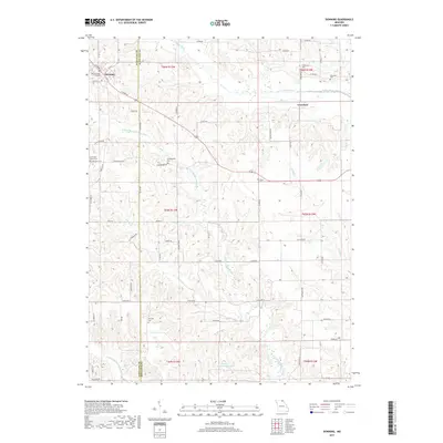
2017 Map of Downing
USGS Topo · Published 2017About this map
The town of Downing anchors the northwest corner of this Missouri landscape, situated near the boundary where Schuyler County meets Scotland County. This rural terrain is deeply dissected by the winding courses of the N Fork Middle Fabius River and the North Fabius River, creating a complex network of ridges and creek valleys. Evidence of the area's pioneer heritage is scattered throughout the township lines, marked by numerous small burial grounds such as McGrady Cem, Dover Cem, and Campground Cem.
Find a feature on this map
64 named features on this map. Tap any name to fly to it.
Don’t see what you’re looking for? This feature index may not catch every label — zoom into the map to look around manually.
Map Details
Editions of this 2017 Downing Map
This is the sole edition of this map. No revisions or reprints were ever made.
Other maps of this area

1903 · Edina
USGS Topo · 1:125,000

1954 · Centerville
USGS Topo · 1:250,000

1957 · Centerville
USGS Topo · 1:250,000

1958 · Centerville
USGS Topo · 1:250,000

1965 · Memphis
USGS Topo · 1:24,000

1965 · Greensburg
USGS Topo · 1:24,000

1965 · Downing NW
USGS Topo · 1:24,000

1966 · Downing
USGS Topo · 1:24,000
1966 · Bible Grove
USGS Topo · 1:24,000
1966 · Willmathsville
USGS Topo · 1:24,000