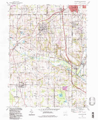
1994 Map of Doylestown
USGS Topo · Published 1997About this map
Doylestown sits at the heart of this topographic landscape, where the agricultural plains of northeast Ohio meet a significant network of underground gas storage and extraction. The survey shows a region defined by its small-town clusters, including Clinton, Marshallville, and Easton, many of which grew along the historic corridor of the Chippewa and Baughman townships. The map records several family and community landmarks essential for local history, such as the Harvey Sch Cem and the Maple Grove Cem, alongside the Filtration Plant and various gravel pits that hint at the local utility and resource industries.
Find a feature on this map
54 named features on this map. Tap any name to fly to it.
Don’t see what you’re looking for? This feature index may not catch every label — zoom into the map to look around manually.
Map Details
Editions of this 1994 Doylestown Map
This is the sole edition of this map. No revisions or reprints were ever made.
Other maps of this area

1901 · Massillon
USGS Topo · 1:62,500

1901 · Wooster
USGS Topo · 1:62,500

1903 · Massillon
USGS Topo · 1:62,500

1903 · Wooster
USGS Topo · 1:62,500

1903 · Akron
USGS Topo · 1:62,500

1904 · Medina
USGS Topo · 1:62,500

1905 · Akron
USGS Topo · 1:62,500

1906 · Medina
USGS Topo · 1:62,500

1950 · Cleveland
USGS Topo · 1:250,000

1951 · Canton
USGS Topo · 1:250,000