
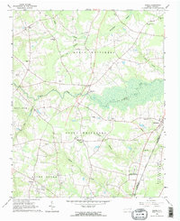
1963 Map of Drake
USGS Topo · Published 1964About this map
North Carolina Wesleyan College stands out as a prominent landmark in the southern reaches of this landscape, just west of the Atlantic Coast Line railroad. This 1963 field-checked survey reveals a rural society structured around family cemeteries and small community centers like Drake, Gold Rock, and Dortches. The terrain is defined by the winding course of Swift Creek and its many tributaries, including Compass Creek and Beech Run, which carve through the townships of North Whitakers and South Whitakers.
Find a feature on this map
45 named features on this map. Tap any name to fly to it.
Don’t see what you’re looking for? This feature index may not catch every label — zoom into the map to look around manually.
Map Details
Editions of this 1963 Drake Map
2 editions found
Other maps of this area

1902 · Rocky Mount
USGS Topo · 1:62,500

1902 · Tarboro
USGS Topo · 1:62,500

1903 · Tarboro
USGS Topo · 1:62,500

1904 · Rocky Mount
USGS Topo · 1:62,500

1953 · Norfolk
USGS Topo · 1:250,000

1953 · Rocky Mount
USGS Topo · 1:250,000

1954 · Rocky Mount
USGS Topo · 1:250,000

1961 · Whitakers
USGS Topo · 1:24,000

1961 · Enfield
USGS Topo · 1:24,000

1963 · Ringwood
USGS Topo · 1:24,000