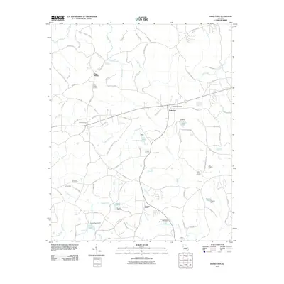
2011 Map of Draketown
USGS Topo · Published 2011About this map
Draketown and Piney Woods anchor this West Georgia landscape, where the headwaters of the Tallapoosa River wind through a complex of small family-named watersheds and agricultural plots. The area is dense with genealogical markers, featuring numerous burial grounds such as Draketown Cemetery, Mount Carmel Cemetery, and Corinth Cemetery. Water management is a defining characteristic of the terrain, visible through a series of engineered structures including Little River Structure Number Seven Dam and the Little Tallapoosa Watershed Dam Number One. This network of small lakes like Garrett Lake and Hatfields Lake suggests a landscape managed for local irrigation and flood control. Transportation is defined by a web of rural routes like Coppermine Rd and Old Draketown Pass, while the Ayresouth Airport provides a modern landing point amidst the traditional homesteads and creek bottoms of the Mill Creek and Brooks Creek valleys.
Find a feature on this map
106 named features on this map. Tap any name to fly to it.
Don’t see what you’re looking for? This feature index may not catch every label — zoom into the map to look around manually.
Map Details
Editions of this 2011 Draketown Map
This is the sole edition of this map. No revisions or reprints were ever made.
Other maps of this area

1889 · Tallapoosa
USGS Topo · 1:125,000

1891 · Marietta
USGS Topo · 1:125,000

1892 · Tallapoosa
USGS Topo · 1:125,000

1895 · Marietta
USGS Topo · 1:125,000

1897 · Marietta
USGS Topo · 1:125,000

1897 · Tallapoosa
USGS Topo · 1:125,000

1901 · Marietta
USGS Topo · 1:125,000

1953 · Atlanta
USGS Topo · 1:250,000

1957 · Atlanta
USGS Topo · 1:250,000

1958 · Atlanta
USGS Topo · 1:250,000