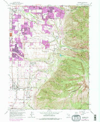
1963 Map of Draper
USGS Topo · Published 1978About this map
Little Cottonwood Canyon serves as a dramatic backdrop for this mid-century portrait of a rapidly expanding Salt Lake Valley. Substantial urban growth is visible across Sandy City, Cottonwood Heights, and Draper, with purple revision tinting indicating the suburban sprawl of the late 1960s and 70s. The landscape maintains a functional connection to its pioneer and religious roots, specifically noted at the Temple Granite Quarry Historical Monument and the LDS Church Records Storage Area tucked into the canyon walls. Infrastructure like the Jordan and Salt Lake City Canal and the Union Pacific railroad define the valley floor, while specialized sites like Carters Sky Ranch and the Mellen Sand Spur highlight the varied industrial and recreational uses of the land before complete residential infill. The transition from the high peaks of Wasatch National Forest to the irrigated valley floor illustrates the regional dependence on mountain runoff.
Find a feature on this map
52 named features on this map. Tap any name to fly to it.
Don’t see what you’re looking for? This feature index may not catch every label — zoom into the map to look around manually.
Map Details
Editions of this 1963 Draper Map
Other maps of this area

1885 · Salt Lake
USGS Topo · 1:250,000

1925 · Ft. Douglas
USGS Topo · 1:125,000

1928 · Ft. Douglas
USGS Topo · 1:125,000

1948 · Timpanogos Cave
USGS Topo · 1:24,000

1948 · Orem
USGS Topo · 1:62,500

1950 · Timpanogos Cave
USGS Topo · 1:24,000

1951 · Jordan Narrows
USGS Topo · 1:24,000

1951 · Lehi
USGS Topo · 1:24,000

1951 · Salt Lake City South
USGS Topo · 1:24,000

1951 · Midvale
USGS Topo · 1:24,000