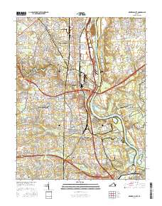
2016 Map of Drewrys Bluff
USGS Topo · Published 2016About this map
The James River snakes through this 2016 survey, defining the industrial and defensive geography south of Richmond. Along the river's western bank, the topographic rise of Drewrys Bluff stands as a prominent landmark within the Richmond National Battlefield Park, echoed across the water by Chaffin Bluff. This landscape is heavily shaped by its military and industrial heritage, with the massive Phillip Morris Drive Way complex and the dense suburban growth of Meadowbrook, Bensley, and Bellwood filling the space between the river and the arterial corridor of Hull Street Rd. Local history is anchored by numerous burial grounds including Salem Cem, Centralia Cem, and Laurel Hill Cem. Water features such as the Falling Cr Reservoir and the winding Proctors Cr illustrate the drainage patterns of the coastal plain as it transitions into the developed outskirts of the Virginia capital.
Find a feature on this map
51 named features on this map. Tap any name to fly to it.
Don’t see what you’re looking for? This feature index may not catch every label — zoom into the map to look around manually.
Map Details
Editions of this 2016 Drewrys Bluff Map
This is the sole edition of this map. No revisions or reprints were ever made.
Other maps of this area

1890 · Goochland
USGS Topo · 1:125,000

1892 · Goochland
USGS Topo · 1:125,000

1894 · Bermuda Hundred
USGS Topo · 1:62,500

1894 · Richmond
USGS Topo · 1:62,500

1895 · Richmond
USGS Topo · 1:62,500

1897 · Amelia
USGS Topo · 1:125,000

1934 · Seven Pines
USGS Topo · 1:24,000

1934 · Richmond
USGS Topo · 1:24,000

1936 · Richmond West
USGS Topo · 1:24,000

1938 · Dutch Gap
USGS Topo · 1:24,000