
1936 Map of Richmond West
USGS Topo · Published 1936About this map
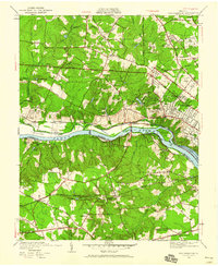
The James River corridor west of Richmond reveals a landscape of transition in the mid-1930s, where river-based industry meets growing suburban estates and academic institutions. The University of Richmond and West Hampton High School anchor the northern banks, while the Chesapeake and Ohio railroad tracks trace the river's path through Bosher and Lorraine. Significant infrastructure like the Bosher Dam and Westham Bridge highlights the area's connection between Henrico, Goochland, and Chesterfield counties.
Find a feature on this map
73 named features on this map. Tap any name to fly to it.
Don’t see what you’re looking for? This feature index may not catch every label — zoom into the map to look around manually.
Map Details
Editions of this 1936 Richmond West Map
2 editions found
Other maps of this area

1890 · Goochland
USGS Topo · 1:125,000

1892 · Goochland
USGS Topo · 1:125,000

1894 · Bermuda Hundred
USGS Topo · 1:62,500

1894 · Richmond
USGS Topo · 1:62,500

1895 · Richmond
USGS Topo · 1:62,500

1897 · Amelia
USGS Topo · 1:125,000

1934 · Richmond
USGS Topo · 1:24,000

1936 · Glen Allen
USGS Topo · 1:24,000

1938 · Drewrys Bluff
USGS Topo · 1:24,000

1938 · Yellow Tavern
USGS Topo · 1:31,680