
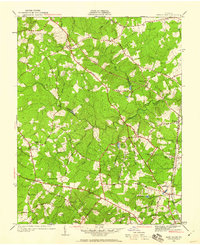
1936 Map of Glen Allen
USGS Topo · Published 1936About this map
The Chickahominy River winds through this central Virginia landscape, defining the boundary between Hanover Co and Henrico Co during the mid-1930s. The settlement at Glen Allen serves as a focal point, supported by the Richmond Fredericksburg and Potomac Railroad and the presence of the Glen Allen High Sch. The map reveals a transition from the developing rail corridor to the rural interior, where historical crossroads like Short Pump and Shady Grove are marked by their namesake schools and churches.
Find a feature on this map
46 named features on this map. Tap any name to fly to it.
Don’t see what you’re looking for? This feature index may not catch every label — zoom into the map to look around manually.
Map Details
Editions of this 1936 Glen Allen Map
2 editions found
Other maps of this area

1890 · Goochland
USGS Topo · 1:125,000

1892 · Goochland
USGS Topo · 1:125,000

1894 · Richmond
USGS Topo · 1:62,500

1895 · Richmond
USGS Topo · 1:62,500

1918 · Doswell
USGS Topo · 1:62,500

1934 · Richmond
USGS Topo · 1:24,000

1936 · Richmond West
USGS Topo · 1:24,000

1938 · Yellow Tavern
USGS Topo · 1:31,680

1939 · Richmond
USGS Topo · 1:31,680

1941 · Glen Allen
USGS Topo · 1:31,680