1961 Map of Drexel
USGS Topo · Published 1976About this map
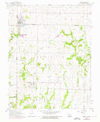
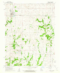
Drexel sits at the northern edge of this borderland survey, established as a railroad town along the Kansas City Southern line. The landscape is defined by the interstate boundary between Kansas and Missouri, where small farming communities like Merwin developed in the early 20th century. The topography is shaped by the winding paths of Sugar Creek and Miami Creek, with agricultural land divided into several distinct townships including West Boone, East Boone, and West Point. Local history is preserved in several rural burial grounds such as West Point Cem, Sharon Cem, and Edgewood Cem, while industrial activity is represented by a Quarry near the center of the quadrangle. The map reflects a mid-century rural economy tied to the rail line and the management of local waterways like Mormon Fork.
Find a feature on this map
24 named features on this map. Tap any name to fly to it.
Don’t see what you’re looking for? This feature index may not catch every label — zoom into the map to look around manually.
Map Details
Editions of this 1961 Drexel Map
2 editions found
Other maps of this area

1887 · Harrisonville
USGS Topo · 1:125,000

1887 · Olathe
USGS Topo · 1:125,000

1887 · Butler
USGS Topo · 1:125,000

1887 · Mound City
USGS Topo · 1:125,000

1892 · Harrisonville
USGS Topo · 1:125,000

1893 · Mound City
USGS Topo · 1:125,000

1893 · Olathe
USGS Topo · 1:125,000

1894 · Harrisonville
USGS Topo · 1:125,000

1894 · Butler
USGS Topo · 1:125,000

1947 · Lawrence
USGS Topo · 1:250,000