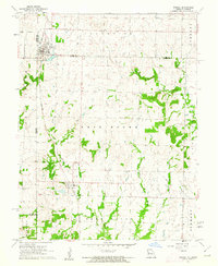
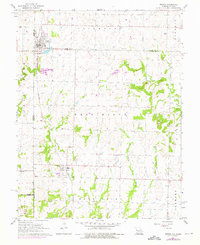
1961 Map of Drexel
USGS Topo · Published 1962About this map
The border town of Drexel straddles the state line in the early 1960s, serving as a focal point for this agrarian region where Kansas City Southern tracks run parallel to the Kansas-Missouri boundary. The landscape is defined by the drainage basins of Morman Fork and Willow Branch, with timber-lined creeks carving through the agricultural townships of Coldwater and West Boone. This survey provides significant genealogical detail for the area, documenting the exact locations of rural burial grounds including Sharon Cem, Edgewood Cem, and West Point Cem. The map's inclusion of fine red dashed lines indicates field and fence lines visible from 1958 aerial photography, offering a precise look at the division of family farms and homesteads before modern consolidation changed the rural layout.
Find a feature on this map
13 named features on this map. Tap any name to fly to it.
Don’t see what you’re looking for? This feature index may not catch every label — zoom into the map to look around manually.
Map Details
Editions of this 1961 Drexel Map
2 editions found
Other maps of this area

1887 · Harrisonville
USGS Topo · 1:125,000

1887 · Olathe
USGS Topo · 1:125,000

1887 · Butler
USGS Topo · 1:125,000

1887 · Mound City
USGS Topo · 1:125,000

1892 · Harrisonville
USGS Topo · 1:125,000

1893 · Mound City
USGS Topo · 1:125,000

1893 · Olathe
USGS Topo · 1:125,000

1894 · Harrisonville
USGS Topo · 1:125,000

1894 · Butler
USGS Topo · 1:125,000

1947 · Lawrence
USGS Topo · 1:250,000