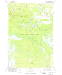
1972 Map of Driggs Lake
USGS Topo · Published 1975About this map
Grand Sable State Forest dominates this landscape in the early 1970s, characterized by a complex network of wetlands and small glacial lakes. The Driggs River and Negro Creek wind through the central lowlands, feeding into the expansive Driggs Marsh. Human presence is primarily defined by resource management and recreation, evidenced by the Wardles Landing Field and Howards Camp in the southern reaches. Local transportation is facilitated by historical logging routes and fire roads such as the Walsh Grade and Driggs Lake Road. The abundance of named water bodies, including Mahoney Lake, Stanley Lake, and Cranberry Lake, illustrates the post-glacial topography typical of this part of the Upper Peninsula. These features, along with the Stanley Lake Campground, highlight the area's role as a destination for outdoor life during this era.
Find a feature on this map
34 named features on this map. Tap any name to fly to it.
Don’t see what you’re looking for? This feature index may not catch every label — zoom into the map to look around manually.
Map Details
Editions of this 1972 Driggs Lake Map
This is the sole edition of this map. No revisions or reprints were ever made.
Other maps of this area

1931 · Driggs Lake NE
USGS Topo · 1:31,680

1931 · Shingleton NE
USGS Topo · 1:31,680

1931 · Driggs Lake NW
USGS Topo · 1:31,680

1931 · Shingleton SE
USGS Topo · 1:31,680

1931 · Driggs Lake SW
USGS Topo · 1:31,680

1931 · Driggs Lake SE
USGS Topo · 1:31,680

1958 · Shingleton
USGS Topo · 1:62,500

1958 · Grand Portal Point
USGS Topo · 1:62,500

1958 · Marquette
USGS Topo · 1:250,000

1960 · Marquette
USGS Topo · 1:250,000