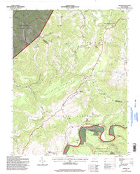
1995 Map of Droop
USGS Topo · Published 1998About this map
Droop Mountain Battlefield State Park dominates the northeastern highlands of this map, marking a significant historical terrain where the Little Levels plateau meets the steep ascent of Droop Mtn. The landscape is a study in contrasting West Virginia topography, transitioning from the broad, agricultural plains of the levels near the settlement of Droop to the heavily forested slopes of the Monongahela National Forest. Along the southern border, the Greenbrier River carves a deep valley, flanked by the steep walls of Falling Spring Mountain. Local history and genealogy are well-represented by numerous rural landmarks, including a Covered Bridge on Locust Creek and a network of country churches and family-named cemeteries such as Beulah Ch, Sunset Cem, and Kellison Cem. Small settlements like Loveridge, Julia, and Modoc are scattered throughout the valleys, connected by winding mountain roads.
Find a feature on this map
52 named features on this map. Tap any name to fly to it.
Don’t see what you’re looking for? This feature index may not catch every label — zoom into the map to look around manually.
Map Details
Editions of this 1995 Droop Map
This is the sole edition of this map. No revisions or reprints were ever made.
Other maps of this area

1887 · Lewisburg
USGS Topo · 1:125,000

1891 · Lewisburg
USGS Topo · 1:125,000

1891 · Huntersville
USGS Topo · 1:125,000

1894 · Huntersville
USGS Topo · 1:125,000

1921 · Callaghan
USGS Topo · 1:48,000

1921 · White Sulphur Springs
USGS Topo · 1:48,000

1923 · Lobelia
USGS Topo · 1:48,000

1923 · White Sulphur Springs
USGS Topo · 1:62,500

1923 · Marlinton
USGS Topo · 1:48,000

1923 · Callaghan
USGS Topo · 1:62,500