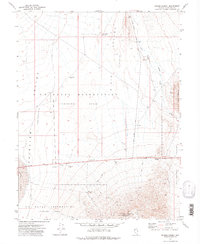
1972 Map of Drumm Summit
USGS Topo · Published 1975About this map
Fairview (Site) sits at the base of a high ridge in this early 1970s survey, marking a place where mining operations once concentrated. The landscape is defined by its industrial and military utility, with the U S Naval Reservation (Training Area) and a dedicated Target Area spanning much of the terrain. High-altitude landmarks like Chalk Mountain and Drumm Summit overlook the Dixie Valley and Fairview Valley depressions, while the presence of a Cem near the Dromedary Hump Mine and several Prospects suggests a history of local habitation tied to mineral extraction. Water management is critical in this arid environment, evidenced by the Aqueduct running alongside the eastern mountains and the Dixie Valley Res No 2 to the north. A prominent Fault line traces through the Stingaree Valley, indicating the active geological character of this Churchill County region.
Find a feature on this map
26 named features on this map. Tap any name to fly to it.
Don’t see what you’re looking for? This feature index may not catch every label — zoom into the map to look around manually.
Map Details
Editions of this 1972 Drumm Summit Map
2 editions found
Other maps of this area

1908 · Carson Sink
USGS Topo · 1:250,000

1910 · Carson Sink
USGS Topo · 1:250,000

1957 · Reno
USGS Topo · 1:250,000

1959 · Reno
USGS Topo · 1:250,000

1960 · Reno
USGS Topo · 1:250,000
1972 · Bell Mountain
USGS Topo · 1:24,000

1972 · Pirouette Mtn
USGS Topo · 1:24,000
1972 · Wonder Mountain
USGS Topo · 1:24,000
1972 · Bell Canyon
USGS Topo · 1:24,000
1972 · West Gate
USGS Topo · 1:24,000