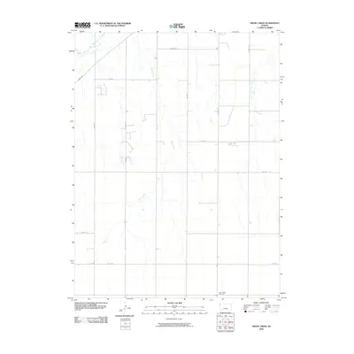
2009 Map of Drury Creek
USGS Topo · Published 2009About this map
The South Fork Republican River cuts through the northwest corner of this Cheyenne County landscape, where the high plains terrain is defined by intermittent drainages and a rigid grid of country roads. Agriculture and ranching dominate the character of the region, as evidenced by the sparse, deliberate placement of infrastructure. In the southeast, Lawn Ridge Cemetery serves as a significant local landmark, situated at the junction of Co Rd 15 and Co Rd F. This point of interest provides a focal point for genealogical research in an area otherwise characterized by the winding paths of Drury Creek and West Fork Sand Creek. The network of thoroughfares, including River Rd and various numbered county routes, facilitates movement across this open landscape, connecting isolated homesteads to the wider geographic context of western Kansas.
Find a feature on this map
17 named features on this map. Tap any name to fly to it.
Don’t see what you’re looking for? This feature index may not catch every label — zoom into the map to look around manually.
Map Details
Editions of this 2009 Drury Creek Map
This is the sole edition of this map. No revisions or reprints were ever made.
Other maps of this area

1942 · St. Francis
USGS Topo · 1:62,500

1943 · St. Francis
USGS Topo · 1:62,500

1951 · St Francis
USGS Topo · 1:62,500

1951 · Bird City North
USGS Topo · 1:62,500

1951 · Bird City South
USGS Topo · 1:62,500

1952 · St Francis 3
USGS Topo · 1:62,500

1954 · Goodland
USGS Topo · 1:250,000

1956 · Goodland
USGS Topo · 1:250,000

1957 · Goodland
USGS Topo · 1:250,000
1978 · St Francis
USGS Topo · 1:24,000