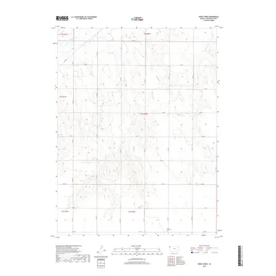
2018 Map of Drury Creek
USGS Topo · Published 2018About this map
S Fork Republican River winds through the northwestern corner of this Kansas landscape, defining the hydrology of a region dominated by wide drainage basins and periodic watercourses. The map illustrates a highly organized grid of rural roads and section lines typical of the High Plains, where the terrain is etched by seasonal tributaries like Drury Cr and the W Fork Sand Cr. These intermittent streams flow through a series of north-south valleys, separated by broad upland ridges. This 2018 survey reveals the persistent agricultural and ranching patterns of Cheyenne County, where human infrastructure is largely limited to a network of county roads including Co RD M, Co RD G, and Co RD E, which connect isolated homesteads and provide access across the undulating prairie.
Find a feature on this map
1 named feature on this map. Tap any name to fly to it.
Don’t see what you’re looking for? This feature index may not catch every label — zoom into the map to look around manually.
Map Details
Editions of this 2018 Drury Creek Map
This is the sole edition of this map. No revisions or reprints were ever made.
Other maps of this area

1942 · St. Francis
USGS Topo · 1:62,500

1943 · St. Francis
USGS Topo · 1:62,500

1951 · St Francis
USGS Topo · 1:62,500

1951 · Bird City North
USGS Topo · 1:62,500

1951 · Bird City South
USGS Topo · 1:62,500

1952 · St Francis 3
USGS Topo · 1:62,500

1954 · Goodland
USGS Topo · 1:250,000

1956 · Goodland
USGS Topo · 1:250,000

1957 · Goodland
USGS Topo · 1:250,000
1978 · St Francis
USGS Topo · 1:24,000