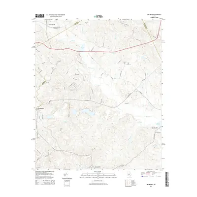
2014 Map of Dry Branch
USGS Topo · Published 2014About this map
The community of Griswoldville and the winding reaches of Big Sandy Cr define the northern portion of this central Georgia landscape. The map details a transition from the rolling terrain near the Jones and Twiggs County line toward the lower drainage basins of Wolf Cr and Game Cr in the south. Several established settlements including Dry Branch, Fitzpatrick, and Myricks Mill serve as focal points for the local road network, which includes historically significant routes like Old Griswoldville Rd and Georgia Kaolin Rd.
Find a feature on this map
88 named features on this map. Tap any name to fly to it.
Don’t see what you’re looking for? This feature index may not catch every label — zoom into the map to look around manually.
Map Details
Editions of this 2014 Dry Branch Map
This is the sole edition of this map. No revisions or reprints were ever made.
Other maps of this area

1956 · Gordon
USGS Topo · 1:62,500

1956 · Warner Robins
USGS Topo · 1:62,500

1956 · Jeffersonville
USGS Topo · 1:62,500

1956 · Macon East
USGS Topo · 1:24,000

1956 · Macon
USGS Topo · 1:62,500

1957 · Macon
USGS Topo · 1:250,000

1958 · Macon
USGS Topo · 1:250,000

1964 · Macon
USGS Topo · 1:250,000
1973 · Gordon
USGS Topo · 1:24,000

1973 · Massey Hill
USGS Topo · 1:24,000