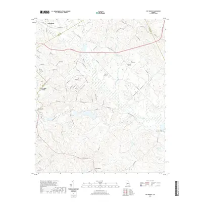
2020 Map of Dry Branch
USGS Topo · Published 2020About this map
Griswoldville and Dry Branch anchor this 2020 landscape where the borders of Bibb, Twiggs, Jones, and Wilkinson counties converge. The terrain is defined by the drainage of Big Sandy Cr and Wolf Cr, which create a complex network of wetlands and small ponds like Jolly Pond and Birdsong Pond. This modern survey reveals a deeply established rural cemetery network that includes Tharp Cem, Antioch Cem, and Nelson Cem, offering significant value for genealogists tracing family roots in Middle Georgia. The presence of Myricks Mill in the eastern section and the crossing of the Fall Line Fwy indicate how historic water-powered industry has given way to modern regional transportation corridors. Scattered family settlements are evident through roads like Kitchens Rd and Rawlins Rd, which connect these small communities through the creek-dissected hillsides of the Macon-Bibb County line.
Find a feature on this map
86 named features on this map. Tap any name to fly to it.
Don’t see what you’re looking for? This feature index may not catch every label — zoom into the map to look around manually.
Map Details
Editions of this 2020 Dry Branch Map
This is the sole edition of this map. No revisions or reprints were ever made.
Other maps of this area

1956 · Gordon
USGS Topo · 1:62,500

1956 · Warner Robins
USGS Topo · 1:62,500

1956 · Jeffersonville
USGS Topo · 1:62,500

1956 · Macon East
USGS Topo · 1:24,000

1956 · Macon
USGS Topo · 1:62,500

1957 · Macon
USGS Topo · 1:250,000

1958 · Macon
USGS Topo · 1:250,000

1964 · Macon
USGS Topo · 1:250,000
1973 · Gordon
USGS Topo · 1:24,000

1973 · Massey Hill
USGS Topo · 1:24,000