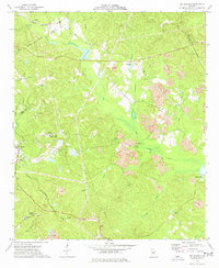
1973 Map of Dry Branch
USGS Topo · Published 1977About this map
Industrial kaolin mining and agricultural history intersect in this 1973 survey of northern Twiggs County. Extensive Clay Pits, Tailings Ponds, and a network of claypits dominate the central landscape, illustrating the region's economic reliance on mineral extraction. The community of Griswoldville sits near the northern boundary along the Georgia Central rail line, while Dry Branch and Fitzpatrick anchor the southwestern corridor.
Find a feature on this map
41 named features on this map. Tap any name to fly to it.
Don’t see what you’re looking for? This feature index may not catch every label — zoom into the map to look around manually.
Map Details
Editions of this 1973 Dry Branch Map
2 editions found
Other maps of this area

1956 · Gordon
USGS Topo · 1:62,500

1956 · Warner Robins
USGS Topo · 1:62,500

1956 · Jeffersonville
USGS Topo · 1:62,500

1956 · Macon East
USGS Topo · 1:24,000

1956 · Macon
USGS Topo · 1:62,500

1957 · Macon
USGS Topo · 1:250,000

1958 · Macon
USGS Topo · 1:250,000

1964 · Macon
USGS Topo · 1:250,000
1973 · Gordon
USGS Topo · 1:24,000

1973 · Massey Hill
USGS Topo · 1:24,000