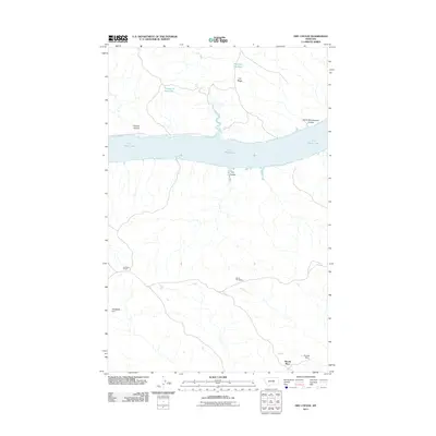
2011 Map of Dry Coulee
USGS Topo · Published 2011About this map
Fort Peck Lake dominates this central Montana landscape, where the wide water intersects a network of rugged drainages and family holdings. The map detail reflects a history of ranching and early 21st-century water management, featuring several small-scale engineering works such as Headman Dam, Ox Yoke Dam, and the Big Rock Reservoir. Notable landform labels like Garrit Schoolhouse Coulee hint at the locations of former community centers now preserved only in name. Family lineages are grounded in the terrain at McArthur Ranch, Novak Homestead, and Woods Place, illustrating the isolated settlement pattern typical of the Missouri River country. The northern half of the map is defined by the high ground of C K Ridge and the winding course of C K Creek feeding into the main lake.
Find a feature on this map
13 named features on this map. Tap any name to fly to it.
Don’t see what you’re looking for? This feature index may not catch every label — zoom into the map to look around manually.
Map Details
Editions of this 2011 Dry Coulee Map
This is the sole edition of this map. No revisions or reprints were ever made.
Other maps of this area

1954 · Lewistown
USGS Topo · 1:250,000

1959 · Lewistown
USGS Topo · 1:250,000

1965 · Karsten Coulee
USGS Topo · 1:24,000

1965 · Dry Coulee
USGS Topo · 1:24,000

1965 · Chain Buttes
USGS Topo · 1:24,000
1965 · Weingart Place
USGS Topo · 1:24,000

1965 · Lake Reservoir
USGS Topo · 1:24,000

1965 · Weingart Place NW
USGS Topo · 1:24,000

1971 · Blizzard Reservoir
USGS Topo · 1:24,000

1971 · Hanson Flat
USGS Topo · 1:24,000