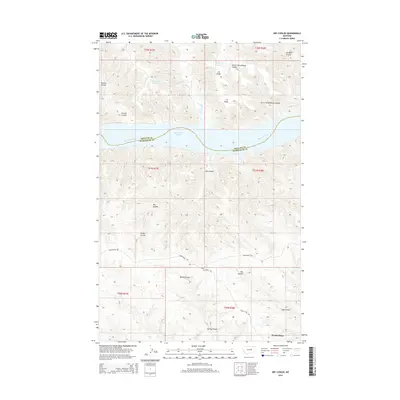
2014 Map of Dry Coulee
USGS Topo · Published 2014About this map
Missouri River and Fort Peck Lake anchor this landscape along the boundary of Phillips and Petroleum counties. The terrain is defined by a dense network of drainages and topographical features named for early ranching and homesteading efforts, including the prominent C K Ridge and the deeply etched Dry Coulee. Near the southern edge, Woods Place represents a focal point of human activity in this otherwise sparse region, while several reservoirs such as Timber Pit Reservoir and Big Rock Reservoir underscore the critical importance of water management in this arid environment.
Find a feature on this map
24 named features on this map. Tap any name to fly to it.
Don’t see what you’re looking for? This feature index may not catch every label — zoom into the map to look around manually.
Map Details
Editions of this 2014 Dry Coulee Map
This is the sole edition of this map. No revisions or reprints were ever made.
Other maps of this area

1954 · Lewistown
USGS Topo · 1:250,000

1959 · Lewistown
USGS Topo · 1:250,000

1965 · Karsten Coulee
USGS Topo · 1:24,000

1965 · Dry Coulee
USGS Topo · 1:24,000

1965 · Chain Buttes
USGS Topo · 1:24,000
1965 · Weingart Place
USGS Topo · 1:24,000

1965 · Lake Reservoir
USGS Topo · 1:24,000

1965 · Weingart Place NW
USGS Topo · 1:24,000

1971 · Blizzard Reservoir
USGS Topo · 1:24,000

1971 · Hanson Flat
USGS Topo · 1:24,000