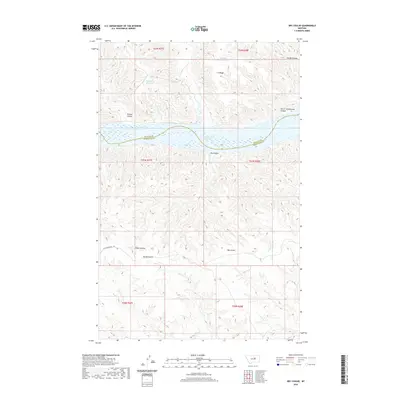
2020 Map of Dry Coulee
USGS Topo · Published 2020About this map
Fort Peck Lake dominates this central Montana landscape, where the waters of the Missouri River reservoir separate Phillips and Petroleum counties. The surrounding badlands are defined by a network of drainage features like Nichols Coulee and Garrit Schoolhouse Coulee, suggesting the agricultural and educational history of early ranching families. Significant evidence of historical transit remains visible through the Old Musselshell Trl, which winds across the southern plateaus near Fisher Coulee and Spring Coulee. High ground is marked by C K Ridge, providing a vantage point over the complex system of coulees and upland water sources like Big Rock Reservoir and Timber Pit Reservoir. This map reflects a remote ranching territory where the topography dictated both movement and settlement patterns along the breaks of the lake.
Find a feature on this map
19 named features on this map. Tap any name to fly to it.
Don’t see what you’re looking for? This feature index may not catch every label — zoom into the map to look around manually.
Map Details
Editions of this 2020 Dry Coulee Map
This is the sole edition of this map. No revisions or reprints were ever made.
Other maps of this area

1954 · Lewistown
USGS Topo · 1:250,000

1959 · Lewistown
USGS Topo · 1:250,000

1965 · Karsten Coulee
USGS Topo · 1:24,000

1965 · Dry Coulee
USGS Topo · 1:24,000

1965 · Chain Buttes
USGS Topo · 1:24,000
1965 · Weingart Place
USGS Topo · 1:24,000

1965 · Lake Reservoir
USGS Topo · 1:24,000

1965 · Weingart Place NW
USGS Topo · 1:24,000

1971 · Blizzard Reservoir
USGS Topo · 1:24,000

1971 · Hanson Flat
USGS Topo · 1:24,000