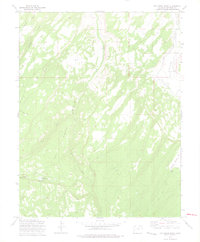
1973 Map of Dry Creek Basin
USGS Topo · Published 1975About this map
Shavano Valley and the expansive Dry Creek drainage dominate this 1970s landscape on the Uncompahgre Plateau. The western portion of the map is defined by the high-elevation basin where the West Fork Dry Creek and East Fork Dry Creek converge, a region marked by numerous Jeep Trails and historic routes like the Transfer Road. The mapping reveals a complex water management system crucial to the region's agricultural viability, featuring the West Canal and the Dry Creek Ditch. To the southwest, the Olathe Reservoir No 1 and Olathe Reservoir No 2 serve as localized water storage points in this arid terrain. These features illustrate the infrastructure required to support high-desert ranching and farming in the shadow of the Basin rim. Landform names like Temple Park and family-named watercourses like Cushman Creek provide specific landmarks for researchers tracing the historical footprint of land use in Montrose County.
Find a feature on this map
19 named features on this map. Tap any name to fly to it.
Don’t see what you’re looking for? This feature index may not catch every label — zoom into the map to look around manually.
Map Details
Editions of this 1973 Dry Creek Basin Map
2 editions found
Other maps of this area

1909 · Montrose
USGS Topo · 1:125,000

1911 · Montrose
USGS Topo · 1:125,000

1955 · Olathe
USGS Topo · 1:24,000

1956 · Montrose
USGS Topo · 1:250,000

1956 · Moab
USGS Topo · 1:250,000

1959 · Moab
USGS Topo · 1:250,000

1959 · Montrose
USGS Topo · 1:250,000

1960 · Montrose
USGS Topo · 1:250,000

1960 · Moab
USGS Topo · 1:250,000

1962 · Moab
USGS Topo · 1:250,000