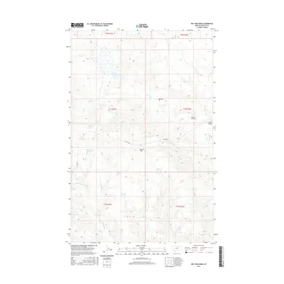
2017 Map of Dry Fork Ridge
USGS Topo · Published 2017About this map
Dry Fork Ridge dominates this portion of Phillips County, serving as a high point between the seasonal drainages of northern Montana. The landscape is characterized by an extensive network of water management features, including Veseth Reservoir and the Hoverson Reservoir, which illustrate the critical importance of water storage in this arid ranching environment. Named coulees and creeks like Garey Coulee and Beauchamp Cr carve through the terrain, while the presence of the Buckhorn Pit and Turkey Track Pit indicates localized resource extraction. Transportation is centered on Dry Fork Rd, which provides the primary access through the drainage basins of the W Fork Dry Fork Cr. The map's layout of section lines and reservoirs such as Wrangler Reservoir and Bog Reservoir offers a clear view of how the land has been partitioned and utilized for agricultural and grazing purposes.
Find a feature on this map
25 named features on this map. Tap any name to fly to it.
Don’t see what you’re looking for? This feature index may not catch every label — zoom into the map to look around manually.
Map Details
Editions of this 2017 Dry Fork Ridge Map
This is the sole edition of this map. No revisions or reprints were ever made.
Other maps of this area

1954 · Lewistown
USGS Topo · 1:250,000

1959 · Lewistown
USGS Topo · 1:250,000

1965 · Karsten Coulee
USGS Topo · 1:24,000

1965 · Veseth Reservoir
USGS Topo · 1:24,000

1965 · Dry Fork Ridge
USGS Topo · 1:24,000
1965 · Holzhey Reservoir
USGS Topo · 1:24,000
1965 · Barber Coulee
USGS Topo · 1:24,000

1965 · Lake Reservoir
USGS Topo · 1:24,000

1971 · Bison Bone Reservoir
USGS Topo · 1:24,000
1971 · Coburn Butte
USGS Topo · 1:24,000