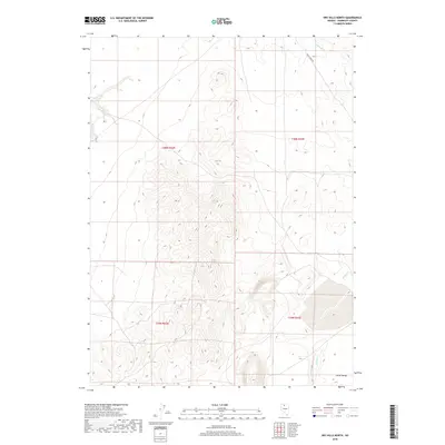
2018 Map of Dry Hills North
USGS Topo · Published 2018About this map
Clover Valley dominates the southern reaches of this Humboldt County landscape, where the high desert terrain transitions into a wide alluvial floor. This 2018 survey documents the intricate drainage patterns of the region, specifically the seasonal courses of Chimney Cr and Rabbit Creek. The map provides a clear look at the sparse infrastructure of this ranching and grazing country, anchored by the path of Kelly Creek Rd as it skirts the foothills. The western portion of the quadrangle is defined by the steep, rising topography of the Dry Hills, with dozens of drainages feeding toward the valley below. While primary settlements are absent from this specific section, the detailed contour lines and public land survey boundaries for townships like t39n r43e offer a precise baseline for understanding land use and cattle-country geography in Northern Nevada.
Find a feature on this map
9 named features on this map. Tap any name to fly to it.
Don’t see what you’re looking for? This feature index may not catch every label — zoom into the map to look around manually.
Map Details
Editions of this 2018 Dry Hills North Map
This is the sole edition of this map. No revisions or reprints were ever made.
Other maps of this area

1882 · Paradise
USGS Topo · 1:250,000

1893 · Paradise
USGS Topo · 1:250,000

1945 · Osgood Mountains
USGS Topo · 1:62,500

1945 · Hot Springs
USGS Topo · 1:62,500

1947 · Osgood Mountains
USGS Topo · 1:62,500

1947 · Hot Springs Peak
USGS Topo · 1:62,500

1955 · McDermitt
USGS Topo · 1:250,000

1959 · McDermitt
USGS Topo · 1:250,000
1980 · Layton Spring
USGS Topo · 1:24,000

1980 · Dry Hills South
USGS Topo · 1:24,000