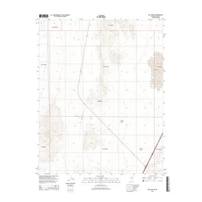
2014 Map of Dry Lake NW
USGS Topo · Published 2014About this map
The Arrow Canyon Range dominates the central topography of this Clark County landscape, where the shifting elevations of the Mojave Desert transition into the low-lying Dry Lake Valley. The eastern edge of the quadrangle is defined by the significant footprint of Dry Lake, a prominent ephemeral feature that anchors the surrounding basin. Modern infrastructure has begun to mark this arid corridor, as seen in the development of Apex Power Pky and Belcher Blvd. These routes indicate the expansion of utilities and access into the valley, providing a clear view of how land management and power distribution networks are integrated into the desert environment. The grid of the Public Land Survey System overlaying these natural features highlights the precise township and range divisions that govern this section of southern Nevada.
Find a feature on this map
14 named features on this map. Tap any name to fly to it.
Don’t see what you’re looking for? This feature index may not catch every label — zoom into the map to look around manually.
Map Details
Editions of this 2014 Dry Lake NW Map
This is the sole edition of this map. No revisions or reprints were ever made.
Other maps of this area

1886 · Saint Thomas
USGS Topo · 1:250,000

1893 · Saint Thomas
USGS Topo · 1:250,000

1907 · Las Vegas
USGS Topo · 1:250,000

1908 · Las Vegas
USGS Topo · 1:250,000

1926 · Boulder Canyon
USGS Topo · 1:96,000

1945 · Sheep Range
USGS Topo · 1:125,000

1952 · Gass Peak
USGS Topo · 1:62,500

1952 · Dry Lake
USGS Topo · 1:62,500

1954 · Las Vegas
USGS Topo · 1:250,000

1957 · Las Vegas
USGS Topo · 1:250,000