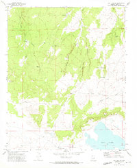
1971 Map of Dry Lake NW
USGS Topo · Published 1973About this map
Dry Lake and a vast basin known as the Depression dominate the southern portion of this Navajo County landscape, where the water management systems of the high desert are clearly visible. The terrain is defined by a network of seasonal water catchments including Chamise Tank, Bell Cow Tank, and Red Tank, which supported cattle and regional ranching operations in the early 1970s. Rising abruptly from the basin floor, the Pink Cliffs create a sharp geographic boundary above the depression. To the north, the land is dissected by numerous drainages such as Bell Cow Canyon, Willow Patch Draw, and Pour Off Canyon. Evidence of mid-century industrial activity is present through the Big Oil Well Tank and Small Oil Well Tank, while scattered Jeep Trail paths provide the primary access through this arid environment. For researchers, these named tanks and wells like Eskimo Well offer specific markers of land use and water rights in this part of Arizona.
Find a feature on this map
21 named features on this map. Tap any name to fly to it.
Don’t see what you’re looking for? This feature index may not catch every label — zoom into the map to look around manually.
Map Details
Editions of this 1971 Dry Lake NW Map
This is the sole edition of this map. No revisions or reprints were ever made.
Other maps of this area

1886 · Holbrook
USGS Topo · 1:250,000

1893 · Holbrook
USGS Topo · 1:250,000

1954 · Holbrook
USGS Topo · 1:250,000

1955 · St. Joseph 2 SE
USGS Topo · 1:24,000

1955 · Joseph City
USGS Topo · 1:62,500

1957 · Holbrook
USGS Topo · 1:250,000

1958 · Holbrook
USGS Topo · 1:250,000

1960 · Holbrook
USGS Topo · 1:250,000

1970 · Red Knoll
USGS Topo · 1:24,000
1970 · McCauley Sinks
USGS Topo · 1:24,000