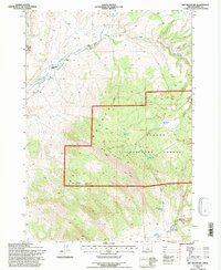
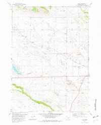
1992 Map of Dry Mountain
USGS Topo · Published 1997About this map
The Ochoco National Forest dominates the high-elevation landscape of Harney County on this 1990s-era topographic survey. The terrain is marked by a complex system of water management, visible through numerous small-scale catchments and developed springs like Big Ridge Reservoir, Big Meadow Reservoir, and the Seeding Waterhole. These features, alongside the Whipsaw Truck Trail, illustrate the infrastructure required for land management and cattle ranching in this remote section of Oregon. The Upper Valley provides a clear view of the transition from open grazing land at Upper Valley Ranch to the steeper, forested slopes of Dry Mountain and Big Ridge. Historical markers like the Gaging Station on Wickiup Creek and the Lookout on Big Ridge provide specific data points for researchers tracing forest service history and resource monitoring at the end of the 20th century.
Find a feature on this map
24 named features on this map. Tap any name to fly to it.
Don’t see what you’re looking for? This feature index may not catch every label — zoom into the map to look around manually.
Map Details
Editions of this 1992 Dry Mountain Map
This is the sole edition of this map. No revisions or reprints were ever made.
Other maps of this area

1955 · Burns
USGS Topo · 1:250,000

1958 · Burns
USGS Topo · 1:250,000

1959 · Burns
USGS Topo · 1:250,000

1959 · Sawtooth Creek
USGS Topo · 1:62,500

1961 · Delintment Lake
USGS Topo · 1:62,500
1981 · Egypt Canyon
USGS Topo · 1:24,000
1981 · Oakerman Lakes
USGS Topo · 1:24,000

1981 · Camp Currey Spring
USGS Topo · 1:24,000
1981 · Suntex
USGS Topo · 1:24,000
1981 · Riley
USGS Topo · 1:24,000