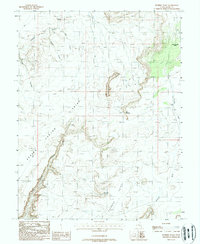
1988 Map of Dubinky Wash
USGS Topo · Published 1988About this map
Dubinky Wash and the surrounding high desert of Grand County are defined by a complex network of deep drainages and prominent mesas in this late-1980s survey. The landscape is dominated by massive geographic features like Canyon Point and Deadman Point, while localized landmarks such as The Needles provide orientation in the arid terrain. For those researching land use and resource exploration, several locations are marked simply as Drill Hole, signifying the industrial or geological probing of the era.
Find a feature on this map
15 named features on this map. Tap any name to fly to it.
Don’t see what you’re looking for? This feature index may not catch every label — zoom into the map to look around manually.
Map Details
Editions of this 1988 Dubinky Wash Map
This is the sole edition of this map. No revisions or reprints were ever made.
Other maps of this area

1885 · San Rafael
USGS Topo · 1:250,000

1885 · La Sal
USGS Topo · 1:250,000

1951 · The Knoll
USGS Topo · 1:62,500

1952 · Tidwell 4 SE
USGS Topo · 1:24,000

1952 · Moab 3 NE
USGS Topo · 1:24,000

1952 · Moab 3 SE
USGS Topo · 1:24,000

1952 · Tidwell 4 NE
USGS Topo · 1:24,000

1952 · Moab 3 SW
USGS Topo · 1:24,000

1952 · Moab 3 NW
USGS Topo · 1:24,000

1954 · Tidwell 1 SE
USGS Topo · 1:24,000