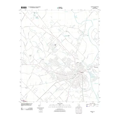
2011 Map of Dublin
USGS Topo · Published 2011About this map
The Oconee River serves as the primary geographical divider for this region in the early 21st century, separating the city of Dublin from East Dublin. The landscape reveals a mix of established municipal infrastructure and newer residential developments like Holly Hills. Local history and genealogy are well-represented by numerous burial sites, including the Old Dublin Cemetery, Northview Cemetery, and Dubley Cemetery, providing clear spatial context for family researchers.
Find a feature on this map
91 named features on this map. Tap any name to fly to it.
Don’t see what you’re looking for? This feature index may not catch every label — zoom into the map to look around manually.
Map Details
Editions of this 2011 Dublin Map
This is the sole edition of this map. No revisions or reprints were ever made.
Other maps of this area

1957 · Macon
USGS Topo · 1:250,000

1958 · Macon
USGS Topo · 1:250,000

1964 · Macon
USGS Topo · 1:250,000

1974 · Cow Hell Swamp
USGS Topo · 1:24,000

1974 · Rentz
USGS Topo · 1:24,000

1974 · Dudley
USGS Topo · 1:24,000

1974 · East Dublin
USGS Topo · 1:24,000
1974 · Nicklesville
USGS Topo · 1:24,000
1974 · Dexter
USGS Topo · 1:24,000

1974 · Lovett
USGS Topo · 1:24,000