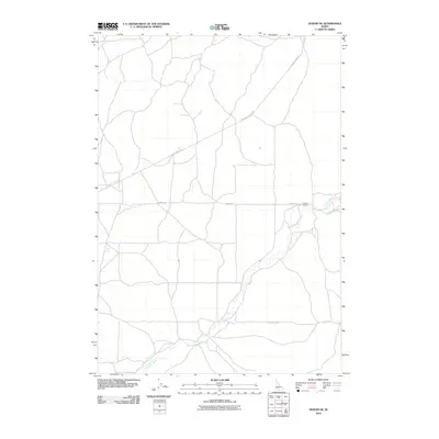
2010 Map of Dubois NE
USGS Topo · Published 2010About this map
Camas Creek meanders through the heart of this landscape in Fremont County, defining the drainage and topography of this high-elevation Idaho terrain. The settlement pattern here is sparse, characterized by larger agricultural and ranching holdings such as Jacoby Ranch. This 2010 survey by the U.S. Geological Survey captures a network of rural roads that serve the ranching economy, including the primary corridor of A-2 Clark County Rd and smaller connectors like Jacoby Rd and Gravy Ridge Rd. The map illustrates the fundamental relationship between water sources and settlement in the American West, where the creek's path dictates the placement of infrastructure and private property boundaries.
Find a feature on this map
5 named features on this map. Tap any name to fly to it.
Don’t see what you’re looking for? This feature index may not catch every label — zoom into the map to look around manually.
Map Details
Editions of this 2010 Dubois NE Map
This is the sole edition of this map. No revisions or reprints were ever made.
Other maps of this area

1955 · Dubois
USGS Topo · 1:250,000

1955 · Ashton
USGS Topo · 1:250,000

1958 · Dubois
USGS Topo · 1:250,000

1958 · Ashton
USGS Topo · 1:250,000

1960 · Ashton
USGS Topo · 1:250,000

1964 · Dubois NW
USGS Topo · 1:24,000

1964 · Dubois NE
USGS Topo · 1:24,000

1964 · Camas
USGS Topo · 1:24,000
1964 · Dubois SE
USGS Topo · 1:24,000

1972 · Spencer South
USGS Topo · 1:24,000