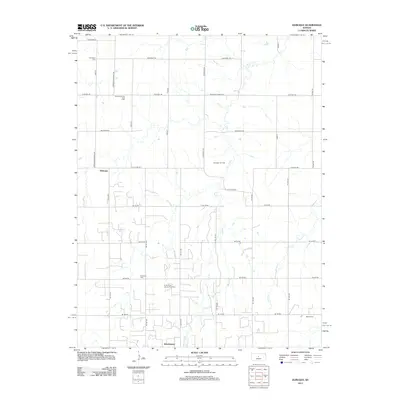
2012 Map of Dubuque
USGS Topo · Published 2012About this map
Dubuque and Hitschmann anchor this prairie landscape in Barton County, where the agricultural grid meets a significant energy infrastructure. The map reveals an area where traditional farming life exists alongside active extraction, evidenced by the Driscoll Oil and Gas Field and the Kraft-Prusa Oil and Gas Field. These industrial zones are interspersed with quiet reminders of the area's early settlers, including the Dubuque Cem, Bethel Cem, and Immanuel Cem. The terrain is drained by the meandering paths of Coal Cr and Blood Cr, which cut through the rectilinear road system of Winterset Rd and Stickney Rd. This 2012 survey illustrates the modern Kansas plains as a functional landscape of local commerce and resource management, maintaining its historical identity through named junctions and small rural settlements.
Find a feature on this map
35 named features on this map. Tap any name to fly to it.
Don’t see what you’re looking for? This feature index may not catch every label — zoom into the map to look around manually.
Map Details
Editions of this 2012 Dubuque Map
This is the sole edition of this map. No revisions or reprints were ever made.
Other maps of this area

1894 · Ellsworth
USGS Topo · 1:125,000

1896 · Russell
USGS Topo · 1:125,000

1955 · Great Bend
USGS Topo · 1:250,000

1956 · Wilson
USGS Topo · 1:24,000

1956 · Dorrance
USGS Topo · 1:24,000

1956 · Dorrance SW
USGS Topo · 1:24,000

1957 · Great Bend
USGS Topo · 1:250,000

1958 · Great Bend
USGS Topo · 1:250,000
1964 · Holyrood NW
USGS Topo · 1:24,000
1964 · Holyrood
USGS Topo · 1:24,000