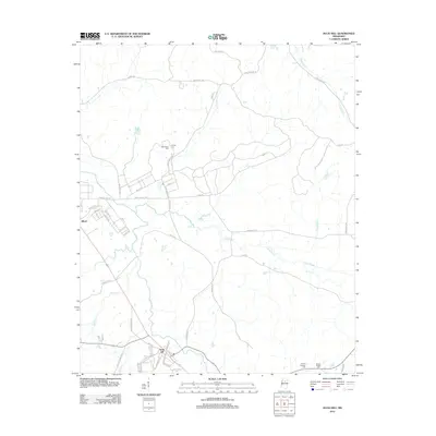
2012 Map of Duck Hill
USGS Topo · Published 2012About this map
Duck Hill sits at the southern edge of this Montgomery County landscape, where the local road network converges near Bogue Cr. To the northwest, the settlement of Elliott marks the boundary of a region defined by a dense network of tributaries including Little Bogue, Crowder Cr, and Redgrass Cr. The map reveals a rural character shaped by generational land use, evident in several family and community landmarks. Genealogists and local historians can find the locations of Bethlehem Cem and Purnell Cem nestled along the winding country lanes such as James H Biddy Rd. The terrain is also marked by legacy infrastructure like Fire Tower Rd and the access routes surrounding Camp McCain Rd, reflecting the area's mid-century development and land management patterns.
Find a feature on this map
56 named features on this map. Tap any name to fly to it.
Don’t see what you’re looking for? This feature index may not catch every label — zoom into the map to look around manually.
Map Details
Editions of this 2012 Duck Hill Map
This is the sole edition of this map. No revisions or reprints were ever made.
Other maps of this area

1953 · West Point
USGS Topo · 1:250,000

1954 · Grenada
USGS Topo · 1:62,500

1954 · Duck Hill
USGS Topo · 1:62,500

1954 · McCarley
USGS Topo · 1:62,500

1955 · Coffeeville
USGS Topo · 1:62,500

1958 · West Point
USGS Topo · 1:250,000

1963 · West Point
USGS Topo · 1:250,000
1983 · Tie Plant
USGS Topo · 1:24,000
1983 · Eskridge
USGS Topo · 1:24,000
1983 · Duck Hill
USGS Topo · 1:24,000