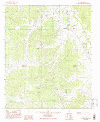
1983 Map of Tie Plant
USGS Topo · Published 1983About this map
The industrial and rural landscape of north-central Mississippi converges at Tie Plant, a settlement named for the railroad infrastructure that defined the local economy during the early 1980s. The Illinois Central Gulf railroad serves as the primary corridor through the region, running parallel to the winding waters of Batupan Bogue. This map captures a borderland where three counties—Grenada, Carroll, and Montgomery—meet among the drainage basins of Collins Creek and Jumping Gulley Creek. Genealogists will find a high density of rural burial grounds and sanctuaries, such as Payne Chapel Cem and Hardiman Chapel, which anchor the smaller communities of Glenwild and Elliott. The southern portion of the map near Salem reveals a landscape transitioning into ridges like Riser, where family-named landmarks such as Purnell Cem and Wilkins Cem reflect generations of local settlement.
Find a feature on this map
38 named features on this map. Tap any name to fly to it.
Don’t see what you’re looking for? This feature index may not catch every label — zoom into the map to look around manually.
Map Details
Editions of this 1983 Tie Plant Map
This is the sole edition of this map. No revisions or reprints were ever made.
Other maps of this area

1953 · West Point
USGS Topo · 1:250,000

1954 · Grenada
USGS Topo · 1:62,500

1954 · Duck Hill
USGS Topo · 1:62,500

1954 · McCarley
USGS Topo · 1:62,500

1955 · Coffeeville
USGS Topo · 1:62,500

1958 · West Point
USGS Topo · 1:250,000

1963 · West Point
USGS Topo · 1:250,000
1983 · Jefferson
USGS Topo · 1:24,000
1983 · Eskridge
USGS Topo · 1:24,000
1983 · North Carrollton
USGS Topo · 1:24,000