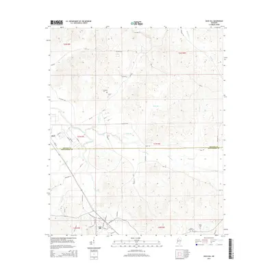
2015 Map of Duck Hill
USGS Topo · Published 2015About this map
The town of Duck Hill serves as the focal point of this Montgomery County landscape, situated where the terrain begins its transition into the drainage basins of the Big Bogue and Little Bogue. This 2015 survey reveals a traditional North Mississippi settlement pattern, with the town's street grid, including Main ST and Carrollton ST, anchored by the north-south corridor of Duck Hill Rd. To the north, the smaller community of Bethlehem is marked by the Purnell Cem, while the western edge reaches the community of Elliott.
Find a feature on this map
49 named features on this map. Tap any name to fly to it.
Don’t see what you’re looking for? This feature index may not catch every label — zoom into the map to look around manually.
Map Details
Editions of this 2015 Duck Hill Map
This is the sole edition of this map. No revisions or reprints were ever made.
Other maps of this area

1953 · West Point
USGS Topo · 1:250,000

1954 · Grenada
USGS Topo · 1:62,500

1954 · Duck Hill
USGS Topo · 1:62,500

1954 · McCarley
USGS Topo · 1:62,500

1955 · Coffeeville
USGS Topo · 1:62,500

1958 · West Point
USGS Topo · 1:250,000

1963 · West Point
USGS Topo · 1:250,000
1983 · Tie Plant
USGS Topo · 1:24,000
1983 · Eskridge
USGS Topo · 1:24,000
1983 · Duck Hill
USGS Topo · 1:24,000