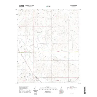
2021 Map of Duck Hill
USGS Topo · Published 2021About this map
Duck Hill anchors this region of the north-central Mississippi hill country, situated just south of the Grenada Co Montgomery Co line. The landscape is defined by an intricate drainage system including the Batupan Bogue, Big Bogue, and Little Bogue, which carve through the terrain alongside numerous smaller tributaries like Crowder Cr and Sykes Creek. This topography influenced the development of local transport, with routes like Greensboro Rd and Providence Rd following the natural ridges and valleys.
Find a feature on this map
58 named features on this map. Tap any name to fly to it.
Don’t see what you’re looking for? This feature index may not catch every label — zoom into the map to look around manually.
Map Details
Editions of this 2021 Duck Hill Map
This is the sole edition of this map. No revisions or reprints were ever made.
Other maps of this area

1953 · West Point
USGS Topo · 1:250,000

1954 · Grenada
USGS Topo · 1:62,500

1954 · Duck Hill
USGS Topo · 1:62,500

1954 · McCarley
USGS Topo · 1:62,500

1955 · Coffeeville
USGS Topo · 1:62,500

1958 · West Point
USGS Topo · 1:250,000

1963 · West Point
USGS Topo · 1:250,000
1983 · Tie Plant
USGS Topo · 1:24,000
1983 · Eskridge
USGS Topo · 1:24,000
1983 · Duck Hill
USGS Topo · 1:24,000