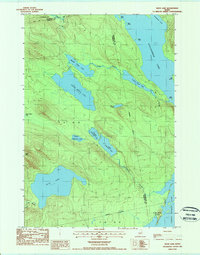
1987 Map of Duck Lake
USGS Topo · Published 1988About this map
A dense network of glacial lakes and interconnected waterways defines this interior Maine landscape along the border of Penobscot, Hancock, and Washington counties. Central to the area is Duck Lake, situated just south of the prominence of Duck Mtn. The hydrology is complex, featuring the cascading sequence of Upper Unknown Lake, Middle Unknown Lake, and Lower Unknown Lake, which feed into Unknown Stream. In the northern section, the terrain is dominated by the long reaches of Sysladobsis Lake and the various basins of the Chain Lakes system, including Upper Chain Lake and Lower Chain Lake. These waters are connected by Chain Stream, while several islands such as Big Island and Birch Island dot the larger lakes. The map reflects a remote timberland character, where few roads exist beyond 4WD tracks and town boundaries like Lakeville represent the primary human imprint.
Find a feature on this map
30 named features on this map. Tap any name to fly to it.
Don’t see what you’re looking for? This feature index may not catch every label — zoom into the map to look around manually.
Map Details
Editions of this 1987 Duck Lake Map
This is the sole edition of this map. No revisions or reprints were ever made.
Other maps of this area

1931 · Springfield
USGS Topo · 1:48,000

1932 · Nicatous Lake
USGS Topo · 1:48,000

1934 · Nicatous Lake
USGS Topo · 1:62,500

1934 · Springfield
USGS Topo · 1:62,500

1941 · Scraggly Lake
USGS Topo · 1:62,500

1941 · Wabassus Lake
USGS Topo · 1:62,500

1943 · Wabassus Lake
USGS Topo · 1:62,500

1944 · Scraggly Lake
USGS Topo · 1:62,500

1953 · Wabassus Lake
USGS Topo · 1:62,500

1954 · Millinocket
USGS Topo · 1:250,000