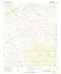
1967 Map of Dugas
USGS Topo · Published 1968About this map
Dugas and its immediate surroundings represent a specialized ranching and forest-service landscape in the high desert of Yavapai County during the late 1960s. The map illustrates a network of essential water management features across the Prescott National Forest and Tonto National Forest, defined by numerous tanks and wells like Grapevine Well and Upper Dry Pasture Tank. This infrastructure supported remote outposts such as the Sycamore Ranger Station and working cattle operations like the T Anchor Ranch and Indian Creek Ranch. The presence of the Old Mine Windmill and scattered prospects suggest a history of resource exploration woven into the rugged topography of Rice Peak and Little Sycamore Canyon. Researchers can trace the intersection of government forestry oversight and private ranching interests, evidenced by the distinct fence lines and the proximity of ranger facilities to family-named landmarks and springs.
Find a feature on this map
49 named features on this map. Tap any name to fly to it.
Don’t see what you’re looking for? This feature index may not catch every label — zoom into the map to look around manually.
Map Details
Editions of this 1967 Dugas Map
3 editions found
Other maps of this area

1887 · Verde
USGS Topo · 1:250,000

1887 · Prescott
USGS Topo · 1:250,000

1892 · Verde
USGS Topo · 1:250,000

1892 · Prescott
USGS Topo · 1:250,000

1903 · Bradshaw Mountains
USGS Topo · 1:125,000

1929 · Turret Peak
USGS Topo · 1:125,000

1933 · Turret Peak
USGS Topo · 1:125,000

1947 · Bumblebee
USGS Topo · 1:62,500

1947 · Mayer
USGS Topo · 1:62,500

1948 · Bumblebee
USGS Topo · 1:63,360