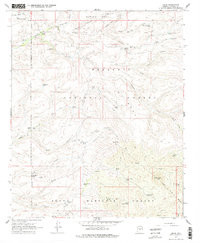
1967 Map of Dugas
USGS Topo · Published 1978About this map
Dugas and the T Anchor Ranch sit at the northern edge of this high-elevation landscape, where the administrative presence of the Sycamore Ranger Station oversees a transition between the Prescott National Forest and the Tonto National Forest. The map detail reveals a complex network of water management essential for ranching and forest operations, featuring numerous catchments like Chalk Tank, Mesa Tank, and Rock Spr Draw Tank. Drainage systems including Little Sycamore Creek and Long Gulch carve through the terrain, punctuated by high points such as Rice Peak and Granite Peak. Evidence of earlier land use appears at the Old Mine Windmill, while several springs, including Willow Spring and Silver Creek Spring, indicate the vital natural water sources that sustained this remote Arizona interior.
Find a feature on this map
44 named features on this map. Tap any name to fly to it.
Don’t see what you’re looking for? This feature index may not catch every label — zoom into the map to look around manually.
Map Details
Editions of this 1967 Dugas Map
3 editions found
Other maps of this area

1887 · Verde
USGS Topo · 1:250,000

1887 · Prescott
USGS Topo · 1:250,000

1892 · Verde
USGS Topo · 1:250,000

1892 · Prescott
USGS Topo · 1:250,000

1903 · Bradshaw Mountains
USGS Topo · 1:125,000

1929 · Turret Peak
USGS Topo · 1:125,000

1933 · Turret Peak
USGS Topo · 1:125,000

1947 · Bumblebee
USGS Topo · 1:62,500

1947 · Mayer
USGS Topo · 1:62,500

1948 · Bumblebee
USGS Topo · 1:63,360